
Order Without Design by Alain Bertaud (Book Review)
Overview
I have wanted to read Alain Bertaud’s book Order Without Design: How Markets Shape Cities for quite some time. I first heard about Alain after he appeared on Econtalk and Conversations with Tyler several years ago. Although I stopped working as a housing economist five years ago, I have maintained my interest in issues of urban economics (see here here, here, here, or here). Bertaud is a popular figure amongst market urbanists because he criticizes the zoning regulations from an urban planners perspective. The title of the book and the choice of quotes in the first chapter hint at Bertaud’s political sympathies:
Nations stumble upon establishments, which are indeed the result of human action, but not the execution of any human design. (Adam Ferguson)
Order generated without design can far outstrip plans men consciously contrive. (Frederick Hayek)
The core argument of Order Without Design is that urban planning has failed as a profession because it has drawn inspiration from the wrong discipline: design rather than economics. As a result:
[The] professionals in charge of modifying market outcomes through regulations (planners) know very little about markets, and the professionals who understand markets (urban economists) are seldom involved in the design of regulations aimed at restraining these markets.
Instead of acting like central bankers in charge of the land supply – changing zoning policy in response to vacancy rates or price to income ratios – urban planners set themselves qualitative goals like “sustainability”, “resilience”, or “equity”. Such goals, while admirable in principle, are designed to make accountability impossible. According to Bertaud, urban planners should be primarily focused on building public infrastructure which will maximize labour market efficiency. He points, rightly in my view, that the point of cities is to provide job opportunities.[1]
Urban planners should be held responsible for unaffordable high price/income ratios in the same way that public health officials are held responsible for infectious disease epidemics, or police are held responsible for high crime.
Bertaud’s first realization that planning rules may actually hurt the society came as a junior planner in post-colonial Algeria. He noticed that the Code de l’urbanisme, which was developed with the suburbs of Paris in mind, was poorly suited to the needs and economic resources of a poor North African society. Most of his value as a planner was from granting exceptions to the planning code, rather than enforcing it. Although Bertaud sends off libertarian signals (by quoting Hayek for example), he makes it clear that he does believe in some regulations:
I do not advocate “deregulation” as an ideological doctrine… Auditing urban regulations is like periodically pruning a tree: the objective is not to cut branches but to allow the tree to fully develop.
The second epiphany for Bertaud came when he was working with an urban economist Jim Wright in Haiti in 1974 as part of a UN-sponsored master plan for Port-au-Prince. At the time, Bertaud was unaware of the difference between economists and accountants. Through his interactions with Wright, Bertaud came to realize that land prices, densities, and the built form could all be accounted for with economic theories.
Some readers might think that I may have been an exceptionally ignorant urban planner. I do not think that I was exceptional: I was rather typical in my ignorance. In the planning profession, high land prices are often deplored but are usually thought to be caused by speculators. To this day, few planners make a connection between land prices and rents, and the supply of land and floor space. That is why planners who design regulations that severely limit the extension of cities are often surprised by increasing land prices and attribute them to external factors for which they were not responsible.[2]
The mental models of urban planners
The design culture of urban planning often bumps up against the messy reality of human choice and incentives. A city’s population growth cannot be “planned” because it is endogenously determined: the number of people that want to come to a city will be a function of its housing costs, job opportunities, and amenities. According to Bertaud, some planners see the growth of urban boundaries beyond their aesthetic preference as “cancerous”. The large slum population of Mumbai (more than 5 million people) is a result of Mumbai’s municipal authorities refusing to build basic infrastructure or grant property rights to inhabited areas outside the city’s prescribed regulations. Slums are always a consequence of planners refusing to accept the behaviour of humans to build dwellings in areas that provide the best economic opportunities. In contrast to Mumbai, cities like Jakarta have done much better at preventing slums from forming by waiving land use regulations and connecting kampungs to municipal infrastructure.
Order Without Design acknowledges that urban planners have a difficult job: they cannot control the long-run population of their city but they need to build infrastructure to support future population levels. The trend in post-industrial economies has been towards more urbanization and a revitalization of urban cores. The theory that the internet would allow the labour force to spread out across the country has been proven wrong – at least so far. Bertaud is sceptical that telecommuting will dampen this trend. The big unknown of post-COVID life is what percent of the workforce will be able to permanently work remotely. Even if it’s only 10%, this could have a non-trivial impact of small and medium-sized cities. This uncertainty highlights how important it is for zoning laws and “master plans” to be able to adapt to changing economic circumstances.
Whether Bertaud’s criticism of contemporary urban planning today is correct, the history of the discipline is littered with disasters. The “great men” of urban design sought to couch their aesthetic preferences as pseudo-scientific theories. Le Corbusier’s famous Plan Voisin would have replaced Paris’ beloved Belle Epoque architecture with soulless and uniform concrete towers. luckily, Haussmann’s Paris was spared Le Corbuiser’s dystopia (althought the urban poor were not as lucky). The architect/planner’s fatal conceit (put not intended) reached its zenith in the centrally planned economies of the Soviet Union and Communist China. In the Mao era, all buildings had to be built to the “1 hour of sun rule” so that every room in the building received one hour of sun during the winter solstice. This meant that the spacing and height of apartment buildings had to vary between cities on different latitudes! Hence, the population density of housing in Beijing was built to be less than that of Shenzhen regardless of the value of land.
The urban economics approach
Order Without Design would centre urban planning’s focus on two core ideas: mobility and affordability. On an individual (or household) level, mobility is a measure of how long all possible places of employment are, as measured in commuting time. Affordability is the percentage of income an individual (or household) needs to spend to live in their utility-maximizing location. City planners measure their policies in terms of the aggregate impacts on mobility and affordability for the households in their cities. Of course, how these costs are aggregated could be weighted by economic or social considerations.
The standard model of urban economics posits that the price of land will decrease at an exponential rate from the city core. The price of land in turn determines the built form of the city. Because building vertically is more expensive, per square foot of floor, than building horizontally, market forces will encourage buildings to grow taller as land prices increase. Even though zoning regulations have prevented building density from settling to its market equilibrium in most Western cities, the standard model’s predictions of declining prices, floor to area ratios (FARs), and hence population, is an empirical regularity seen in most cities. The exception to this rule can be seen in apartheid cities like Gauteng (Johannesburg and Pretoria) and formerly communist cities like Moscow. Because these cities operated without land prices (in case of the USSR) or without labour rights (Africans and Coloureds couldn’t live in the city centre), the city structure evolved in a way which has reduced the mobility and affordability of the current residents (particularly the most marginalized).
Market urbanists like to point out that in the absence of zoning laws the population density of city would almost certainly increase. However, in the long-run, market forces are likely to lead to a gradual de-densification overall. Land prices reach their peak at the centroid of a city because it takes the shortest amount of time (on average) to get there from different points in the city. As has been noted, higher price will, ceteris paribus, increase the FAR (building height). However, the two primary countervailing forces to density are higher incomes and transportation technology. Residents of a city do not measure their commute in kilometers, but rather the time it takes to get somewhere. For example a new subway line would lower the rate at which prices fell from the city centre (increasing density at areas farther away from the downtown core), but could also lower the price per square foot of the centre. Put another way, if commuters could travel at the speed of light, then land prices and building densities would be uniform. As the residents of a city become wealthier, the demand for housing consumption goes up. We have seen this in the COVID-19 crisis, with the price of detached houses rising as workers able to telecommute demand more housing consumption through a higher willingness to pay. Even though the population densities of a city like Manhattan the City of London appear high, they were even higher in the Victorian era because incomes were lower and transportation technology was limited (most workers had to walk to work).
Some disagreements
Order Without Design is not without its faults. Despite being passionate about urban economics, I found parts of the book boring to read. Bertaud’s use of simple graphs and pedantic discourses of simple formulas provided little information gain beyond what a summary paragraph could have achieved. The book could shed 100 pages without much loss to the reader. Bertaud’s enchantment with economics comes across as naive at some points. There is a vast literature pointing out the various flaws that come with the economics profession’s reliance on stylized models. If a blinkered obsession with mathematical models led economists to miss the financial crisis of 2007–2008, underestimate the costs from foreign trade on workers, and the distributional consequence of monetary policy, we should be wary of its undiluted application in setting the rules of urban design.
Bertaud is critical of urban growth boundaries if they attempt to prevent agricultural land from being turned into residential development. He acknowledges that government policies like fuel subsidies or corrupt eminent domain laws are often to blame for urban sprawl (because they artificially lower the value of agricultural land). As long as these policy failures are corrected, Bertaud is happy for land to be used for its highest marginal value. Unfortunately the value of some land uses is either too difficult to internalize with a price mechanism (like ecosystems) or has asymmetric costs (agricultural land can be converted in urban land but not vice versa) that it seems prudent for governments to create green belts or agricultural land reserves. For example, in Canada, most of the population lives close to the 49th parallel, which is also where most of the prime agricultural land resides. Does it make sense that agricultural land which will pay economic dividends for hundreds of years should be permanently converted into a weekend retreat for wealthy urbanites? As was the case with Britain in WWII, being dependent of foreign food supplies places your national security at risk. Short of having the Royal Navy, there is a national security advantage in having sufficient domestic food production. The simple economic models do not always capture the complexities of policy choices.
But the preservation of agricultural land can go too far. Bertaud points to Hanoi’s Master Plan which won an award from the American Institute of Architects for its “scientific design principles”:
The words “markets” or “land prices” do not appear even once in the entire report, in spite of the declared strategy of the Government of Vietnam to increase the use of market mechanisms to allocate resources.
The plan preserves a huge swath of agricultural land by creating a secondary urban centre that would be connected to downtown Hanoi with highways and trains. As Bertaud points out, farmers will quickly give up rice farming and simply rent out their land to tenants who would prefer a short 20 minute motorcycle commute to get to their job.
Allocating urban land and activities is not a pure design exercise: It requires an understanding of how labour and land markets work. It is impossible to design the future expansion of a city without taking into account the impact of the labour and land markets on the future distribution of the population. Land prices, rents, and commuting times are not mentioned even once in the master plan’s nearly thousand pages of text, maps, and tables. It is a rather typical document that exposes the hubris of planners who think that a city needs only to be designed by a clever engineer, without taking into account market mechanisms that are constantly at play.[3]
Confusing objectives with constraints
City official plans often focus on the need to reduce traffic congestion or the number of commuters. While there are some good reasons for this (reduced infrastructure costs and carbon emissions), the fundamental problem of congestion is that it reduces mobility: the time it takes to get from one part of the city to another. For example, replacing motor vehicles with a slow bus system may reduce congestion, but it won’t help with mobility.[4] Planners who see congestion as a problem to be solved in and of itself, often advocate a “jobs-housing balance”, which means fragmenting the labour market geographically. For example Toronto’s official plan states:
Preserving Employment Areas contributes to a balance between employment and residential growth so that Torontonians have a greater opportunity to live and work in the City, rather than commuting distances to jobs outside of the City. As Employment Areas are spread across the City, work destinations and commuting direction are also spread out, resulting in less road congestion in any one direction. This provides workers who live in close proximity to Employment Areas with the opportunity for shorter commutes to work by either transit, cycling or walking.
But as Bertaud points out, in a market economy the labour market churn is immense, and households are frequently moving between and within cities. A worker who is able to walk to her office today, is just as likely to need to travel across the city in five years from now either because she has a new job, or a new house and the same job, or a new job and a new house. Even if municipal planning departments were accountable in terms of tracking the average commute time between years, declining commute times may be a sign that workers in the suburbs are taking jobs that are easier to commute to, even if there are better labour market opportunities in the downtown core. In other words, a city with deteriorating transportation infrastructure may see its commute time go down, but not for a good reason![5]
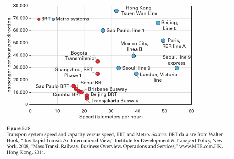
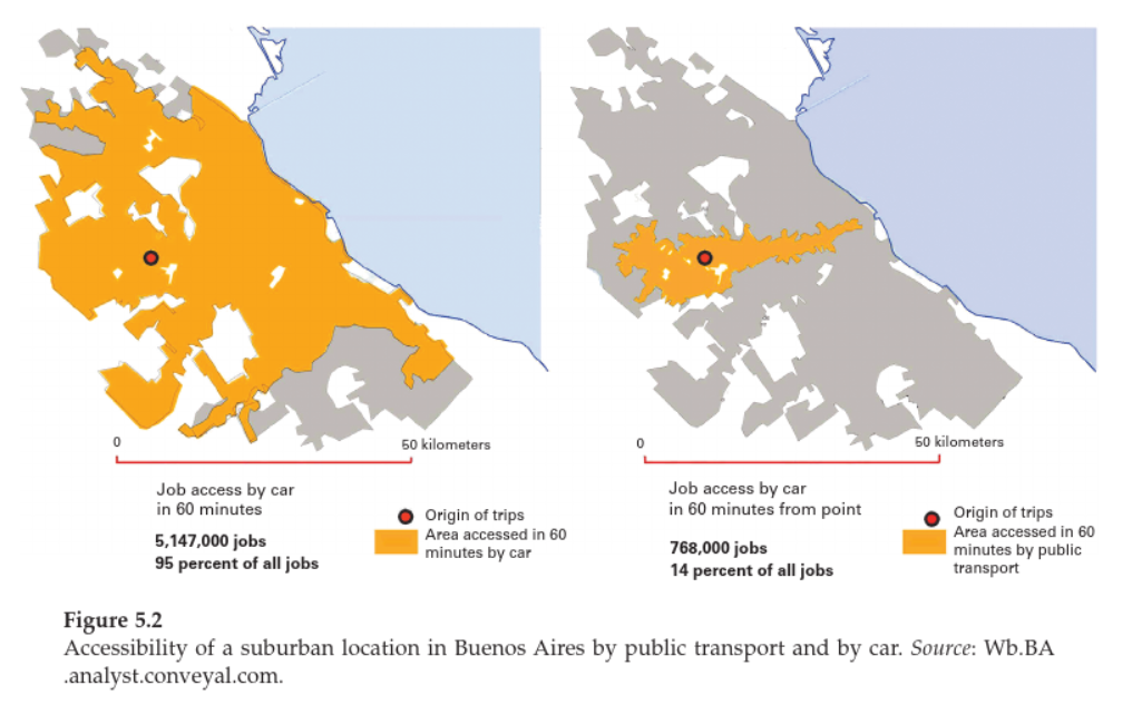
Bertaud is also fairly sceptical of the ability of public transit solutions to solve the problems of congestion. Excluding subways in dense urban cores, public transit options for commuters are almost always slower than driving. For example, 95% of employment sites in Buenos Aires are accessible by a car within a 60 minute commute, whereas the only 14% of jobs are accessible by public transit in the same time frame.
Costs seen an unseen
Governments and bureaucracies have a tendency to favour policies which provide public goods at no seeming expense to the taxpayer. Of course, someone always has to pay. As housing affordability has deteriorated in most large cities, municipalities have increasingly relied on inclusionary zoning to provide affordable housing options.[6] But how do cities get developers to sell below-market priced housing units? If the city owns a piece of valuable real estate, it can include such stipulations in its terms of sale. However the price the city will be able to get from developers will necessarily be lower than what it would have received without such stipulations. In other words, the city is giving up revenue in exchange for a small number of residents getting access to cheap housing. In the case where the land is already developed, cities have to rely on carrots usually in the form of tax incentives or FAR bonuses (i.e. allowing more stories). Tax expenditures on developers is no different than the first case because the city ultimately receives less money than it otherwise would. Fewer tax dollars means either reduced services, higher taxes, or both.
The most opaque approach taken by cities is to increase the FAR (or other density-limiting regulations) to allow developers to build more units on the same land area than they would be able to otherwise. Though the cost of the exclusion appears to be free (if anything it’s a win-win), the broader cost of keeping FAR regulations to prevent other buildings from attaining their market-clearing height causes significant social and economic loss. It amounts to stunting the skyline for some buildings, in order to get developers to build affordable units for other ones.
The costs of inclusionary zoning are paradoxically both substantial and opaque. Because only a small fraction of housing units will ever be built through inclusionary zoning, the economic gains are concentrated to a lucky number of households.[7] It seems clear to me that a municipality which maximized the development fees it extracted from developers by allowing them to build market-based housing in order to build and deliver high-quality transportation infrastructure and public services would benefit far more low income households. What matters for the working poor is not how many kilometres they are from their job, but how long and at what cost it takes them to commute between places. I can easily imagine someone saying: “I don’t trust the government to use that money wisely in a way that will help me.” This is a fair point. Inclusionary zoning may be the low-equilibrium outcome because it forces cities to deliver subsidies to poor households, even if it is an inefficient mechanism and second-best.
At its core, Order Without Design is a call for more accountability into how cities are planned. Since the industrial revolution, cities have been the most important drivers of economic growth and labour market opportunities. The economic output of a single city can rival that of countries. The policy failures of a city like Toronto in Canada or London in the UK have national implications. Governments and citizens will increasingly demand that municipalities make policy choices in the national or regional interest, and that their civil servants are accountable for key indicators.
Without data, anyone who does anything is free to claim success. (Angus Deaton)
Footnotes
-
This is not always true, of course. Some cities are retirement communities, or vacation getaways. However, such small cities can exist only because of the productive wealth generated by other cities and industries. ↩
-
Perhaps today’s planning curriculum is not as bad as Bertaud suggests. For example, UofT’s 2021 Graduate Planning Timetable includes Advanced Quantitative Methods with topics including spatial econometrics. Of course, only a small number of students within the degree may take this course, but there appear to be a mix of quantitative and qualitative courses, although there are more of the latter. ↩
-
Toronto’s Official Plan at least has the word “price” show up two times in the context of housing prices! ↩
-
The choice of a bus system was purely hypothetical, it could be any type of transportation solution. ↩
-
I would be curious if this is case the in Toronto. The population growth of the Toronto CMA has significantly outpaced that of the City of Toronto. Are workers living in the suburbs more likely to find a nearby job to avoid the (nightmare) of Toronto’s highways or unreliable subways? ↩
-
This is somewhat ironic, as I would argue inclusionary zoning is at best an attempt to offset the costs of exclusionary zoning those same cities apply! ↩
-
Bertaud points out that substantial enforcement costs are often required to prevent the beneficiaries of affordable housing units from subletting them out at market rates. ↩